The point of heading out in the wild may be to get away from technology. But mobile apps can help you get to those adventures more quickly, remove the anxiety about getting lost in the woods, and make tracking the fitness gained from your hikes much easier. In this article, you’ll discover three important apps that work together to make any avid hiker’s experience off the beaten path far more enjoyable.
AllTrails: Find, Download, and Track Your Hike
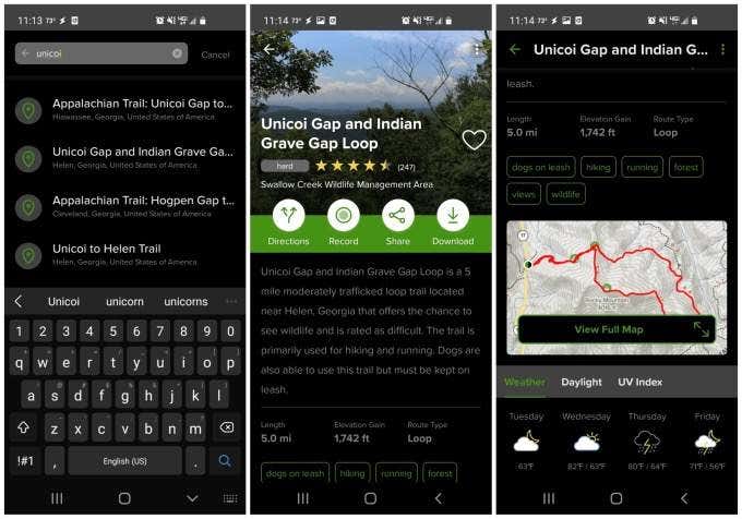
The first and most important hiking app you should download as a hiker is AllTrails. You can download the AllTrails app for Android or for iPhone. You can also access the service via the AllTrails website. AllTrails has one of the most comprehensive libraries of hiking, biking, or running trails all across the world. No matter where you live or are traveling, it’ll tell you where all the best trails are near you. AllTrails trail guides include all of the following information about each trail.
Trail descriptionDifficulty ratingReviewer ratingTrail length, elevation gain, and route typeA map with the trail highlighted in redTrail weather, sunrise and sunset times, and UV indexA collection of reviews by hikers who’ve visited the trail
Note: It’s highly recommended that you subscribe to AllTrails so that you get all of the premium features like no ads, download maps to your phone, map overlays for weather and air quality, and more. It only costs $29.99 per year.
Searching for and Downloading New Trails
From the main page of the app, you can search for trails using either a town or park location or the name of a specific trail you may already know about. When you select any trail in results, you’ll see all of the details listed above. Scroll down to see the map, weather details, trail features, and more. With the premium version, you can select the Download button on the trail detail page. This will download the trail detail page and most importantly, the map that you can use while on the trail, even if you’re off the grid and without a cellular signal.
Accessing and Using Your Downloaded Trails
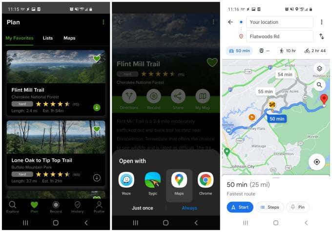
Select Plan at the bottom of the app to see features that’ll let you plan out your next trip. To see your downloaded maps, select Maps from the menu. When you tap the downloaded map that you’re interested in, you’ll see a large view of the map with a blue dot showing your location. You’ll also see the elevation you can expect as you travel along that trail. If you select Download More Layers, you can load additional information onto the downloaded map. Make sure to do this before you head out on the trail and find yourself off the grid. Available map layers include:
RoadSatelliteUSGS TopoTerrainWorld ParksOSM (OpenStreetMap)OCM (Open Cycle Map)
Each layer that you download will appear as an extra overlay of information on top of the original AllTrails map. Note: Keep in mind that each layer you download consumes more of your phone’s storage. So only download only the layers that you absolutely need for your trip. On the trail detail page, you can tap Directions from the menu to see directions to your trailhead. The app will let you choose from any of the navigational apps you have installed on your phone.
Google Maps: Offline Maps to Plan Your Trip
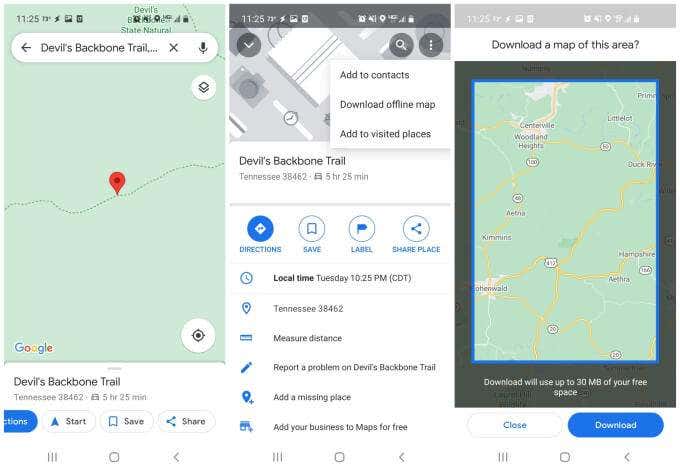
This leads us next to Google Maps. This is the second must-have hiking app for outdoor enthusiasts. This may not seem obvious since most people use Google Maps for driving directions, but Google Maps has one specific feature that’s critical for anyone planning to go exploring off the grid. That feature is the ability to download maps to your phone that you can use even when you’re driving far away from any cell phone towers. To use this feature, it’s best to search for the trail name that you found on AllTrails. This will bring up the trailhead as the destination. Tap the trailhead name at the bottom of the screen to see the location details window. To download the map to that location, tap the three dots at the upper right to open the menu. Select Download offline map from that menu. You’ll see a blue outline appear over the map. Pinch or spread your fingers on this display to resize the map to the area you’d like to download. It’s a good idea to make sure your entire driving route is included so that even if you have to drive outside of cellular coverage en route, Google Maps will still work fine. Select Download to store that map on your phone. Now, the next time you search for and start navigation to that destination, Google Maps will use the map you’ve stored on your smartphone, rather than using cellular data and the internet.
Google Fit: Log Trail Workouts and Fitness Progress
The third must-have hiking app every hiker should use is Google Fit. There are plenty of other fitness apps to choose from, but Google Fit offers simplicity that’s much appreciated when you’re heading out on the trail. Google Fit helps you track your fitness progress as you embark on each hike. To get started, you just have to launch the app, tap the + icon at the lower right, and select Add activity from the pop-up list. This will launch the activity tracking window. Just select the activity from the Activity type box (Walking or Hiking works for walking on trails), then select Start walking to launch the real-time activity tracker. When you’re done hiking, just select the pause and then the stop button under the tracking map. You can tap Journal at the bottom of the app page to see all of the past hikes you’ve gone on. Selecting any of these will show you all of the fitness stats related to that hike. This includes:
The route map with each mile walked indicated by a markerTotal steps accumulated during the hikeTotal time elapsed during the hikeDistance hikedCalories burned
Google Fit also lets you share these hikes. This is especially fun if you’ve reached a hike mileage goal and want to share it with your friends on social media, or just want to text the hike to a few of your friends. To do this, just tap the share icon at the top of the hike description screen. This will open an image of the hike route map. You can edit the appearance of the map and then tap the checkmark to continue. Choose the app you want to choose to share your hike route and Google Fit will open that app to a new post or text message where you can share the hike.
Hiking Apps Will Improve Your Outdoor Adventure
You may be tempted to leave all electronics behind when you head out into the wilderness. But if you bring along your phone and use these three apps, you can track your location, log your hikes, and keep track of your fitness progress. And if you download the maps as described above, you can do all of this completely off the grid. After all, that’s where all of the best hikes can be found.


